
Photo album: "Arrival to Kerguelen"
Fly over a photo with the mouse to enlarge it
Click on a photo to open it in a new window
On Friday October 4th, 1974, we arrive in sight of the Kerguelen archipelago. We make a first stop off Pointe Suzanne to deposit equipment which will be used to construct an automatic measuring station. We start again on Monday October 7th, then Marion-Dufresne enter Golf of Morbihan and anchors in front of Port-aux-Français base. Later, we make a first tour of recognition of the places where we will work during the next six months.
|
On October 4th, 1974, in the afternoon, we sail near the southern costs of Kerguelen archipelago. |
 |
Kerguelen archipelago is situated
in southern Indian Ocean between south latitudes 48°35' and 49°54 and
between east longitudes 68°43' and 70°35', at distances of about 2000 km
from the Antarctic coasts of Massif Gaussberg at south, 3400 km from
Réunion island at north and 4800 km from Australia at east. The
archipelago constitutes one of the four districts(*) of the
French Southern and Antarctic Territories. Its main island, La Grande
Terre, is the third French island, by its dimensions, and the largest of
the sub-Antarctic islands. The archipelago, of volcanic origin, has
numerous isles, bays, inlets, fjords, and coves, as well as several
peninsulas and promontories. Its superficies are about equal at those of
Corsica. Discovered late, at the end of the XVIII century, by Yves Joseph de Kerguelen de Trémarec, these isles which have been given his name have remained, in spite of a few colonization attempts, without permanent inhabitants. They were nicknamed Desolation Islands by the British Captain James Cook who visited them a few years later. Port-aux-Français base, located in Golf of Morbihan, is being permanently occupied since 1950. We can see, on the map, Pointe Suzanne where we made a first stop. (*) a fifth district, "les Iles Eparse", has been added in 2005. |
 |
We continue to sail along southern Kerguelen coasts. A mountain with snowy slopes. |
 |
The journey goes on and the weather changes rapidly during the day. |
 |
When we arrive in front of Pointe Suzanne, the sun is shining again, allowing us to admire the sight. The entrance of Golf of Morbihan is situated behind the dark foreland at left of the photo. |
 |
The helicopter is going to take off to carry the mail to Port-aux-Français base. |
 |
A pontoon is being deposited onto the water to transport the equipments to the shore. It will be towed by a motor boat of Marion-Dufresne. |
 |
On Monday October 7th, 1974, we enter Golf of Morbihan. We pass by an anchored Soviet factory ship. Her function is the retrieval and processing of the fishes caught by the Soviet ships that are fishing around Kerguelen islands. |
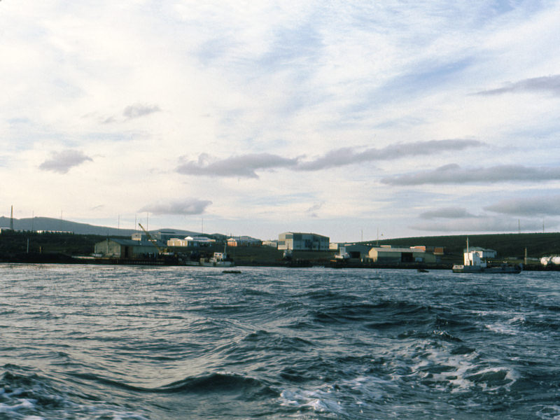 |
At the beginning of the afternoon, Marion-Dufresne anchors in front of Port-aux-Français base. She cannot get alongside the wharf because of the shallow waters near the shore. |
 |
Map of Port-aux-Français base. During winter party, about hundred people live there. During this campaign, we will reach the number of two hundred in January 1975. The road we can see on the right leads onto the plateau where are situated the radio transmission center, the ionosphere station, with its 73-meter high pylon, farther, out of the map limits, the meteorological station, then, the new geophysical laboratory (Géophy) we will have to equip, and finally the CNES base from where the rockets will be launched. |
 |
4 kilometers from the base, we can see for the first time the Géophy lab, built a short time ago and still entirely empty. It will have to be ready to accommodate the French scientists, at the end of December 1974, when the ARAKS experiment will begin. |
 |
Sight from Géophy laboratory: A little farther, on lower ground, is the CNES base. It is from there that two Eridan French rockets and five ARCAS American smaller rockets will be launched. |
 |
Towards Golf of Morbihan, we perceive on the other shore, snow covered summits: on the left, on the background, the Mount Ross (1850 m) and, on the right, much nearer and much lower, "le Pouce". |
 |
Towards Port-aux-Français, on the right, we perceive the pylon of the IONO station antenna (the same as Dumont d'Urville's) and, on the left, the wall to protect the meteorological balloons from the wind during the launching operation (much larger than the one of Dumont d'Urville, because space is not limited here). |
 |
The weather, in Kerguelen, changes very fast and it is not uncommon to see all the seasons succeed in a single day. Rain, snow, sun can follow after another at a few hours interval and the wind, that blows nearly permanently, propels the rain horizontally with the result, when you are outside, you can get wet on one side only. |
 |
The wind has sent the clouds away and a rainbow shows up with the return of the sun. |
.
.
.
.
.
.
.