
Photo album: "From Pokhara to Jomosom"
Fly over a photo with the mouse to enlarge it
Click on a photo to open it in a new window
We left Yves in Kathmadu (we will not see him again). We catch a plane to Pokhara, on May 4th, early morning. Once arrived we find a hotel near the airstrip. The next day while having breakfast, we meet a man (a sherpa from Namche Bazaar) who tell us he participated in, as a porter, in a French expedition up to Annapurna camp I. He agrees to guide us during our trek to Jomosom for 10 Nepalese rupees per day plus food. Departure is decided to 7 a.m., on Monday May 6th. In the meantime we visit the surroundings and we get also to the bank to change money. An anecdote: I changed a 50-US-dollar travellers' cheque and I was given a "pack" of one hundred 5-nepalese-rupee banknotes. That are very convenient because we are well aware that people, during our trek, cannot easily give back the rest, but they make quite a big pack! A few words about our feet: our infected injuries make wearing the "jungle boots" very painful, therefore we will do the most part of the trek with our "thongs". They are not well suited for walking on mountain paths, too, but they make us suffer less. We will bear the shoes only when we will have to walk in water or on particularly difficult ground.
|
We embark, on Mai 4th, 1968, in a DC3 of the Royal Nepal Airlines, to Pokhara (200 km west of Kathmandu). We will stop in another airport south-west of Kathmandu during the journey. We will fly, in total, during a little less than one hour. We will leave Pokhara, walking, on Monday, May 6th and will arrive in Jomosom, on Sunday May 12th after having travelled about 100 km of more or less steep paths. |
 |
On Monday, May 6th. around 7
a.m. we leave Pokhara (altitude 827 m). We walk a long time in a wide valley,
then we climb a steep hill and arrive, around noon, in the village of
Nodhala (unknown altitude). On May 7th, we start around 5:30 and after an ascent followed by a long descent and another ascent, we arrive, around 13:00, in the village of de Tirkhedhunga (1578 m). On May 8th, we start, around 5:45. Soon after, a steep ascent, mainly on steps cut into the rock, leads us 500 m higher. Then, we proceed climbing through forest areas first of oaks, followed by rhododendrons and then bamboos. We reach, shortly after noon, the Ghorapani pass (2928 m), then after a very steep descent, we stop, around 14:30, in the village of Sikha (1922 m). On May 9th, we leave, around 5:45. After a long descent, followed by several ascents and descents, we walk along the rising narrow valley of Kali Gandaki river. We arrive, around 13:15, in the village of Dana (1434 m). |
| On May 10th, since there is no village where we can stop during the
morning, we leave only around 7:40 after breakfast. We continue in the
valley of Kali Gandaki river and we reach, in the afternoon, the village
of Lete (2379 m). On May 11th, we start around 7:45. The valley of Kali Gandaki river has become much wider, now. We arrive, around 13:15, in the village of Tukuche (2593 m). On May 12th, we leave around 8:50, after breakfast. As we are coming back tonight, we have left our rucksacks in the "lodge". The trail is easy and we travel light. We arrive, around 12:10, in Jomosom (2715 m). |
 |
The Douglas DC3 of Royal Nepal Airlines during the intermediate stop between Kathmandu and Pokhara. We are south-west of Kathmadu at a lower altitude, maybe in Bharatpur, but I wasn't able to read the name of the airport because, at the time, devanagari characters had absolutely no meaning to me. On the runway, the earth is covered with dry grass because the monsoon is still a few weeks ahead. The earth on the airstrip in Pokhara is covered with a greener grass because it rains a little oftener there. |
 |
The Phewa lake, near Pokhara. We perceive on the right, through the haze, Machhapuchhare mountain (altitude 6997 m), its name means " fishtail". On the left, behind, we distinguish the Annapurna range which counts 8 summits higher than 7000 metres. Among them, the ones visible during our trek: Annapurna South (7219 m), Annapurna I (8091 m), Nilgiri (7061 m). |
 |
Another view of Phewa lake and the Annapurna range. |
 |
Zooming on the Annapurna range. |
 |
Thatch covered houses in a village during the first day of trek. |
 |
On the first day we encounter a caravan of mules. We will see many others during the trek, the mule is an animal very well fitted to the mountains paths. We will encounter also, nearer to Jomosom, yaks and sometimes men carrying heavy loads on their back, the load being hold in position by a strap leaning on their forehead. |
 |
André, on the right, and our guide Mingma (approximate spelling). He is 21 and is a sherpa from Namche Bazaar valley. |
 |
Downward, we distinguish a bridge, above the torrent, and the path where we will pass. Sometimes we crossed torrents upon a simple tree trunk, on boulders, on bamboo or wooden bridges hanging or not on chains. |
 |
Here, the path has been hollowed out of the rock wall, we can see steps and a low wall in dry stones showing the edge of the path. |
 |
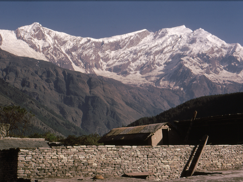
A view of the Annapurna range from the terrace of the house where we will stay overnight, in the village of Lete. The houses, made of stones, are covered with large thin flat stones. |
 |
Another view of Annapurna range. A ladder, made of a tree trunk with carved steps, leads to the terrace, on top of the house. |
 |
Mingma, on the right, and me. We are now, between Lete and Tukuche, in the wide valley of Kali Gandaki river. When the wind blows, it carries dirt and small pebbles which sting our face and uncovered parts of our body. That is very unpleasant. |
 |
We are arrived in Tukuche. In the background, on the right, behind the soccer field, there is a Tibetan monastery with a lama physician. André and Mingma went there to see if it was possible to get some medicine for our injured feet. André came back with seven sticking plasters and he told me that after having given them to him, the lama proposed to sell him a few Tibetan objects. |
 |
Last segment of the trek, between Tukuche and Jomosom. We can see, on the right, the summit of Nilgiri (7061 m). |
 |
We are now in Jomosom where we have shown our "trekking permits" to the local authorities. There has been some discussion because Mingma doesn't have a guide licence, but in the end we succeeded in settling everything. The area beyond Jomosom is under military watch, because of the Chinese problem in Tibet. It is the reason why we couldn't get "trekking permits" to Muktinath, too close to the Tibetan border. André and Mingma are watching a military patrol leaving horseback. |
 |
The patrol is riding away, in the valley of Kali Gandari river, in direction of Muktinath and of the Tibetan border. |
.
.
.
.
.
.
.